Wednesday, September 16, 2009

We’re in Oregon!

Actually, we were in Oregon yesterday, but today we officially moved to an rv park in Troutdale, just outside Portland.  We’re going to stay here for a couple of weeks, then start wandering down the coast.  The park where we’re staying is another very nice one, although the sites are just a little closer together than we like.

Our day trip yesterday took us from Kelso to Astoria, Oregon and down the coast to Cannon Beach.  Jim and I drove our car again so we could take the dogs and not worry about them getting into the picnic bags that Dortha and Mark had in the Jeep.  In Astoria, we stopped to find a quilt shop so I could look at a few patterns. (More about that later).  Then we went out to Fort Stevens State Park to have our picnic lunch and see the shipwreck of the Peter Iredale, a British ship that went aground on the beach in 1906 instead of sailing up the Columbia River to Portland as intended.  This is what’s left of the ship:

Jim 015The next stop was Cannon Beach, where we joined  the hoards of people who take pictures of the famous Haystack Rock:

Jim 061 The parking lot was about a half mile from the rock, but we wanted to walk to it, so off we all went.  Dogs on leash are allowed on the beach, so Jazz and Mr. BJ got to go along.

We timed the arrival just right, because at the base of the rock during low tide, there are some wonderful tide pools.

Jim 085

We got there just at low tide and spent quite a while exploring to see all the creatures:

Jim 081 Once we got back to the rv park, we found that Glenn and Sylvia had arrived and were parked right next to us.  The 8 of us had dinner together and visited until it was time to get some rest.  Glenn and Sylvia were planning to move out to the coast today, while our plans were taking us down to the Portland area.

Since our travel day was only 56 miles, we didn’t hurry this morning, and left just after 10:30.  We arrived at the Sandy Riverfront RV Resort in Troutdale shortly after noon.  This is an interesting park.  It’s the only place we’ve ever stayed where the daily rate is less than a weekly rate would be.  They are also very picky about parking exactly within the boundary of your individual site.  The guy in the office told us if even a tiny bit of your vehicle is over the “sidewalk” it could earn you a $147 fine.  Hmmm….  But other than these quirks, and the close togetherness, it’s a very clean and well-kept place.

Our plans for the area include exploring the Columbia River Gorge, visiting some wineries, catching up on shopping (especially at Trader Joe’s) and visiting with friends who live in the vicinity.  We may tour the “Fruit Loop” and do some other things as well, we’ll see.

About the quilt patterns, we’re having a quilt made for our bed, and I’m trying to figure out just what I want, so I’m looking at all sorts of materials and patterns these days.  Fun!

Tuesday, September 15, 2009

Mt. St. Helens

Yesterday, as I mentioned in our last entry, was the first Sunday of the “real” football season, so I left Jim to his teams and went about my own business, which included laundry (Yes, I did it all!), cleaning up the car, doing some ironing and visiting the local  mall with Dortha.  We each got a great pedicure, then we  hit a few stores.  She found some great bargains, and I did ok myself.

The guys took time out for dinner and we made plans for our trip to Mt. St. Helens.  Our departure time this morning was a little after 10.  We took 2 cars today so that Jim and I could leave the dogs in our car and the food for lunch and snacks would be safe in Dortha and Mark’s car while we were out and about.  With six of us going, it’s a little more comfortable that way too.

We stopped at the visitor’s center to watch a short film about the May 18, 1980 eruption and take a look through the historical exhibits:

Deb and I were browsing through the exhibits:

Jim 005

And Rod took time to read everything:

Jim 007

At our next stop, we decided to go ahead and have our picnic lunch, to which we’d all made contributions. The skies was very overcast and we could not yet see the mountain.  We figured if we took our time getting up to the Johnston Observatory, we’d increase our chances of having the sky clear up so we could see Mt. St. Helens.  We picked out a table and set out our lunch things:

Jim 014

After lunch we continued on up the road towards the Johnston Observatory.  Jim and I visited here in 2003.  Deb and Rod have also been there before, but not since the Observatory was built.  This was Dortha and Mark’s first visit.  It was interesting to see how much greener most of the area is just since we were here.  The trees have really grown back in most areas, although there are still places that are pretty barren, especially right in the blast zone close to the mountain. 

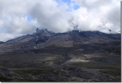
This was all we could see of Mt. St. Helens when we  first got to the observatory.  We went in and watched another film and the exhibits in this center, which are more scientific and explain more about the blast and it’s effects on the landscape.

Jim 044

The observatory was built around this tree, which somehow remained standing after the blast:

Jim 048

Jim had fun pushing the button to activate this exhibit, which is a large table model of the Mt. St. Helens blast area.  It lights up different areas with different  colored lights as a narrated recording explains the events that occurred on the day the volcano erupted:

Jim 050

Something we noticed this visit which we missed before was a small detail, yet very telling.  If you look closely at the dead tree below, you can see large rocks embedded in the roots.  When the blast occurred, these rocks were propelled at about 450 miles an hour into the blown over tree:

Jim 070

We wandered around and walked up a path to a viewing area, hung around and waited, hoping the clouds would lift. Finally:

Jim 063 The clouds started to disperse and we got a  good look at what’s left of Mt. St. Helens.   Impressive!

It was starting to get late, so we headed back towards Kelso.  On the way, though, we stopped to take a picture of a place we’d seen on the way up.

RV Sites – in a pond? Huh?

Jim 080What a great day!  Tomorrow, our day trip is in the other direction – out to Astoria, Oregon.

Saturday, September 12, 2009

Traveling Days

We’ve been on the move since our visit to Forks.  We stayed two nights, Thursday and Friday, at the Hoquiam River RV Park in Hoquiam, Washington.  It’s an interesting little town located on the eastern edge of Gray’s Harbor which is just about in the center of the west coast of the state, but there isn’t much to do there, so our two days in the area were spent first on one side of Gray’s Harbor, in Westport, and the second day in Ocean Shores, on the north side of Gray’s Harbor. 

This was a glimpse of the Pacific Ocean on our way south on Highway 101 from Forks to Hoquiam.

Ellie 019It was a 100 mile trip, complicated by about 10 construction zones.  Thankfully, not all of them meant a delay, but about 4 of them we did have to stop and wait a while.

We got to the rv park, got checked in and set up and headed out towards Westport and the beach:

Jim 030 Jim got there first and took this picture of Mark, Rod and I arriving on the beach:

Jim 011 Near the beach, but just a little inland, is the Westport Light, the tallest lighthouse in Washington:

Ellie 040 After our beach stroll, we stopped and had a seafood dinner at a local place before heading back to the rv park to settle in for the evening.

Friday morning we all caught up with a few things around the house and then headed the other direction to Ocean Shores, which is on the north side of Gray’s Harbor.  We headed right to beach, where Dortha immediately went to get her feet wet:

Jim 017 And Deb started taking pictures:

Jim 012

The surf was really high, but I started right out to get my feet wet too.  Until – a wave came in further and faster than I was expecting.  I started backing up, lost my footing and got knocked down backwards by the force of the wave – and of course, my camera was over my shoulder. We are going to take it to a camera shop as soon as possible, but I don’t have a lot of hope that it’s going to be able to be repaired.  Meantime, I’ll be using my little Olympus camera.

Even though I got pretty well soaked, I managed to get myself dried off and most of the sand brushed off, at least enough to stay and walk the beach a little more, go shopping in some of the local stores, and then on to the casino.  I got a little balance in my day when my name was drawn for a prize.  I had to draw a card each from two different bags and ended up winning $100 cash.  That offset the $40 I lost to the slots, anyway, plus a little.

When we first checked in to the rv park on Thursday, we were informed that Saturday morning the road through town would be a mess because the town would be celebrating Logger’s Play Day with a parade and all sorts of activities.  Since that was our planned travel day, and the road through town is the only one out, we needed to be out of there pretty early to avoid the expected traffic jams.  Somehow we all managed to get up and out a little before 8 a.m. this morning –yes, even Deb and Rod!

We had a very easy 100 mile drive to Kelso, Washington, where we’re staying at Brookhollow RV Park for 4 nights before going on to Oregon.  From here, we’ll visit Mt. St. Helens and the northern Oregon Coast.  This is a really nice rv park with level concrete pads and nicely landscaped grounds. 

Tomorrow is opening Sunday of the NFL, so that is what the guys have planned.  The girls (Dortha, Deb, and I) are thinking of checking out the nearby mall!

Thursday, September 10, 2009

The Hoh Rain Forest

Today’s plan was to start off with brunch at a local Chinese restaurant.  Well, they do have things like egg foo yong, pork fried rice with egg, and egg rolls, don’t they?  So, it’s not as far fetched as it sounds.  Deb and Rod decided to take their truck today, so we went in two vehicles.  Brunch was great, and then we took off for the Hoh Rain Forest which is part of Olympic National Park.  To make the visit more authentic,  it was raining.

We saw this Roosevelt Elk relaxing on a river bank as we got to the park:

Ellie 018 We then made our way to the visitor’s center, where the trails begin:

Ellie 023 We chose the Hall of Mosses trail which is about .8 miles around:

Ellie 028

This fungus grows on the side of the trees:

Ellie 033

Amazing trees with moss that grows all over them:

Jim 044

We decided this was a unicorn:

Jim 049 Jim was dwarfed by the size of the trees:Ellie 073 The sign below describes the tree in the pictures below it.  I took the pictures about halfway down the fallen tree:

Ellie 116

Ellie 112

Then I turned around and took a picture of the half I’d already passed:

Ellie 115

In the rain forest, even though it was raining, we didn’t feel it much through the tree cover.  Mark, Deb and Rod stopped to chat:

Ellie 081 Dortha and I on the trail:

Jim 061 After going through the rain forest, we wanted to visit a tree nearby that is supposed to be the world’s largest red cedar, at over 173 feet tall and 19 feet in diameter.  It’s located about 8 miles from the park and is known as Duncan’s Cedar:Ellie 122 The tree is mostly dead, but there are a few live branches way up near the top:

Ellie 135 Dortha is tiny next to this giant:Ellie 132When we got back to the rv park, the group gathered in the Castle for a happy hour.  I took the dogs out walking, and while we were out, I picked a bunch of blackberries.  Deb is going to make us a cobbler with them.

Tomorrow is another travel day to Hoquiam, Washington.  More adventure awaits!